
PUBLIC NOTICE: Public Hearing Notice Planning & Zoning Commission and City Council City of Wilmer, Texas Feb. 28, 2019
Published one time in the Ellis County Press on Thursday, Feb. 14, 2019.
PUBLIC HEARING NOTICE PLANNING & ZONING COMMISSION and CITY COUNCIL City of Wilmer, Texas
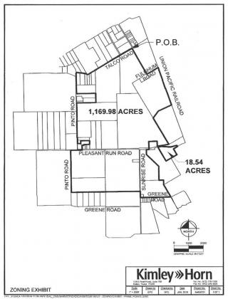
In accordance with Chapter 211 of the Texas Local Government Code, the Planning & Zoning Commission and the City Council of the City of Wilmer, Texas will hold public hearings to consider a zoning request initiated by Prime Rail Interests LLC/WHL Dallas 45 LLC to establish Heavy Industrial (I-2) as the appropriate zoning classification for a 1,170± acre property and for an 18.5± acre property, both of which are generally located west of Millers Ferry Road, south of Talco Road, east of Pinto Road and north of Greene Road, within the City of Wilmer, Texas and also within Dallas County, Texas.
Legal descriptions of the subject land tracts are as follows (detailed metes and bounds descriptions are available for inspection at Wilmer City Hall upon request):
Parcel A (106.6± acres): DCAD #65076744010060000 – Tract 6 in the James S. Lewis Survey, Abstract No. 767, Page 440 (also cited by DCAD as 3701 S. Millers Ferry Road);
Parcel B (4.0± acres):DCAD #65076744010010000 – Tract 1 in the James S. Lewis Survey, Abstract No. 767, Page 440 (also cited by DCAD as 1013 Fulghum Road);
Parcel C(85.3± acres): DCAD #65128578510160000 – Tract 16 in the W.C. Shelton Survey, Abstract No. 1285, Page 785, and also in the Thomas J. Campbell Survey, Abstract No. 299 (also cited by DCAD as 401 Talco Road);
Parcel D (101.5± acres): DCAD #65029934010010000 – Tract 1 in the Thomas J. Campbell Survey, Abstract No. 299, Page 340, and also in the W.C. Shelton Survey, Abstract No. 1285 (also cited by DCAD as 800 Talco Road);
Parcel E (6.0± acres); currently being annexed by Wilmer): DCAD #65029934020010000 – Tract 1 in the Thomas J. Campbell Survey, Abstract No. 299, Page 340 (also cited by DCAD as 912 Talco Road);
Parcel F (2.6± acres): DCAD #65029934020020000 – Tract 2 in the Thomas J. Campbell 9, Page 340 (also cited by DCAD as 902 Talco Road);
Parcel G (2.6± acres); currently being annexed by Wilmer): DCAD #65029934020020200 – Tract 2.2 in the Thomas J. Campbell Survey, Abstract No. 299, Page 340 (also cited by DCAD as 900 Talco Road);
Parcel H (2.8± acres): DCAD #65029934020020100 – Tract 2.1 in the Thomas J. Campbell Survey, Abstract No. 299, Page 340 (also cited by DCAD as 848 Talco Road);
Parcel (6.0± acres): DCAD #650299340200300HS and #65029934020030000 – Tract 3 in the Thomas J. Campbell Survey, Abstract; No. 299, Page 340 (also cited by DCAD as 642 Road);
Parcel J (5.0± acres); currently being annexed by Wilmer): DCAD #650299340200400HS and #65029934020040000 – Tract 4 in the Thomas J. Campbell Survey, Abstract No. 299, Page 340 (also cited by DCAD as 1916 Pinto Road);
Parcel K (18.0± acres): DCAD #65029934020050000 – Tract 5 in the Thomas J. Campbell Survey, Abstract No. 299, Page 340 (also cited by DCAD as 1800 Pinto Road);
Parcel L (81.1± acres): DCAD #65029934010040000 – Tract 4 in the Thomas J. Campbell Survey, Abstract No. 299, Page 340 (also cited by DCAD as 1400 Pinto Road);
Parcel M (27.1± acres): DCAD #65050917510010000 and #65050917510010001 – Tracts 1 & 2 in the John Goar Survey, Abstract No. 509, Page 175 (also cited by DCAD as 1124 Pinto Road);
Parcel N (4.2± acres): DCAD #65050917510140000 – Tract 14 in the John Goar Survey, Abstract No. 509, Page 175 (also cited by DCAD as 1118 Pinto Road);
Parcel O (0.6± acres): DCAD #65050917510140100 – Tract 14.1 in the John Goar Survey, Abstract No. 509, Page 175 (also cited by DCAD as 1112 Pinto Road);
Parcel P (0.6± acres): DCAD #65050917510140200 – Tract 14.2 in the John Goar Survey, Abstract No. 509, Page 175 (also cited by DCAD as 1110 Pinto Road);
Parcel Q (0.4± acres): DCAD #65050917510030000 – part of Tract 3 in the John Goar Survey, Abstract No. 509, Page 175 (also cited by DCAD as 1108 Pinto Road);
Parcel R (0.7± acres): DCAD #54015000010020000 – Lot 2, Block 1 of the Stearns Addition (also cited by DCAD as 1113 W. Pleasant Run Road);
Parcel S (0.7± acres): DCAD #65050917510130000 – Tract 13 in the John Goar Survey, Abstract No. 509, Page 175 (also cited by DCAD as 1001 W. Pleasant Run Road);
Parcel T (0.7± acres): DCAD #65050917510130100 – Tract 13.1 in the John Goar Survey, Abstract No. 509, Page 175 (also cited by DCAD as 1009 W. Pleasant Run Road);
Parcel U (1.5± acres): DCAD #65050917510040000 – Tract 4 in the John Goar Survey, Abstract No. 509, Page 175 (also cited by DCAD as 1005 W. Pleasant Run Road);
Parcel V (16.3± acres): DCAD #65050917510050001 and #65050917510050000 – Tract 5 in the John Goar Survey, Abstract No. 509, Page 175 (also cited by DCAD as 509 E. Pleasant Run Road);
Parcel W (16.5± acres): DCAD #65050917510060001 and #65050917510060000 – Tracts 6 & 6.01 in the John Goar Survey, Abstract No. 509, Page 175 (also cited by DCAD as 505 Pleasant Run Road);
Parcel X (49.7± acres): DCAD #65050917510110000 – Tract 11 in the John Goar Survey, Abstract No. 509, Page 175 (also cited by DCAD as 534 W. Pleasant Run Road);
Parcel Y (212.3± acres): DCAD #65029934010030000 – Tract 3 in the Thomas J. Campbell Survey, Abstract No. 299, Page 340 (also cited by DCAD as 400 E. Pleasant Run Road);
Parcel Z (99.9± acres): DCAD #65112838510030000 – Tract 3 (less ROW) in the Middleton Perry Survey, Abstract No. 1128, Page 385 (also cited by DCAD as 1900 W. Pleasant Run Road);
Parcel Z.1 (53.0± acres): DCAD #65112838510040000 – Tract 4 in the Middleton Perry Survey, Abstract No. 1128, Page 385 (also cited by DCAD as 1300 Pinto Road);
Parcel Z.2 (150.3± acres):DCAD #65050314010010000 – Tract 1 in the Jones Green Survey, Abstract No. 503, Page 140 (also cited by DCAD as 500 W. Pleasant Run Road);
Parcel Z.3 (1.8± acres):DCAD #65050314010040000 – Tract 6 in the Jones Green Survey, Abstract No. 503, Page 140 (also cited by DCAD as 207 Sunrise Road);
Parcel Z.4 (47.7± acres):DCAD #65037980010010000 – Tract 1 in the James Chapman Survey, Abstract No. 379, Page 800 (also cited by DCAD as 100 Sunrise Road);
Parcel Z.5 (47.3± acres):DCAD #65037980010160000 – Tract 16 in the James Chapman Survey, Abstract No. 379, Page 800 (also cited by DCAD as 300 Sunrise Road);
Parcel Z.6 (1.0± acre): DCAD #65037980010110000 – Tract 11 in the James Chapman Survey, Abstract No. 379, Page 800 (also cited by DCAD as 2231 Sunrise Road); and
Parcel Z.7 (18.5± acres):DCAD #65127160010090000 – Tract 9 (less ROW) in the Robert Sloan Survey, Abstract No. 1271, Page 600 (also cited by DCAD as 1101 E. Pleasant Run Road).
Three of the subject properties (Parcels E, G and J) are currently being considered for annexation into the City of Wilmer at the property owner’s request and, if approved, the Heavy Industrial (I-2) zoning classification will then be considered by the City Council and, if approved, will take effect upon completion of annexation proceedings in accordance with the applicable procedures set forth in the Texas Local Government Code.
The first public hearing, and possible consideration/action, on this zoning request will be held before the Wilmer Planning & Zoning Commission on Thursday, February 28, 2019 at 7:00 p.m.
A second public hearing, and possible consideration/action, on this zoning request will be held before the Wilmer City Council on Thursday, March 21, 2019 at 7:00 p.m.
Both public hearings will be held in the regular meeting place, the City of Wilmer Community Center, located at 101 Davidson Plaza in Wilmer, Texas.
All persons interested in the proposed zoning request are invited to attend one or both of the public hearings and to provide their comments at that time.
Comments may also be submitted in writing (or via fax or email) to the City at least 24 hours prior to the beginning of each public hearing at the following address:
Patsy Patten, City Secretary
City of Wilmer, Texas
128 N. Dallas Avenue – Wilmer, Texas 75172
Phone: (972) 441-6373
Fax: (972) 441-3061
Email: ppatten@cityofwilmer.net